
Background: The Fez-Saïs plain and its hills. 1999 - © 2023

Background: Mount Bouyablane (2,742 metres). 1999 - © 2023

An extinct volcano and its plateau in Mimet. 1999 - © 2023

Background: Sefrou and the Binlajraf cliff. 1999 - © 2023
BHALIL. Landscapes in the vicinity of the village. Copyright © 2023
Departure from Casablanca on the Atlantic coast. I wanted to reach Bhalil Village on the continent, with GPS coordinates: North 33° 51' 00" and South 4° 52' 00", about 25 km south of Fez and 3-4 km north-west of Sefrou. The journey from Casablanca to Fez is usually made by train and takes about four hours. The most difficult part is getting from Fez to Bhalil. It's only 25 km away, but it's difficult to get there due to a lack of adequate transport. First of all, there are no trains. And not many buses either. That leaves the large taxis. Usually, an old Mercedes that can carry the driver + 6 passengers. When there aren't many people, it's easy to get a seat. But when there are lots of people, you'd better be physically fit. You have to run after the taxi and be the first to grab the handle if you want to get a seat. We end up packed in like sardines. Travellers arrive in Sefrou in about 30-45 minutes. Next comes the 2ème journey, practically under the same conditions as the previous one. Fortunately, this time the journey is shorter (10-15 minutes), and if you are lucky you will find a larger taxi or the bus that goes to Bhalil. The latter also passes through the centre of Sefrou. This is convenient if you are just running errands on Boulevard Mohammed V, or if you've just come to grab a drink on a café terrace. I've always felt that if you don't have your own transport, the journey from Fez to Bhalil is the most difficult. Especially if you have luggage. It's a bit of an obstacle course.
Leaving the Sefrou basin, the taxi tackles a fairly steep slope for 2 to 3 km to the north-west. The engine of the old German car holds up well. And here we are at our destination: Bhalil Village. The welcome is cool in winter and warm in summer. The entrance to the village is nothing special, except that you still have to climb if you want to reach the upper quarters. The whole village is historically built around a large central spring (Aïn Kbir) that flows at the bottom and foot of two dolomitic limestone cliffs. The small valley that separates the two cliffs is framed by two mosques: one at the bottom next to the water source and the other at the top of the valley and cliffs. There are a few cave dwellings in the cliffs. In the 1960s and 1970s, there was still a species of bird of prey living in these cliffs (a type of falcon or sparrowhawk). Its real local name is ‘Bouamira’. It was said that these birds of prey knew how to smoke. At the time, when a bird of prey fell into the hands of children, they would amuse themselves by putting a cigarette butt in its beak to test this theory.
A forest of olive trees surrounds almost the entire village. Most of the olive trees are in the lower part of Bhalil, where the terrain is less rugged and the soil more fertile. There are also olive trees in the upper part of Bhalil (Binna plateau), where the terrain is flat, clayey, dry and rocky, and therefore less fertile. The yield of olive trees in Bhalil is sometimes twice as high in the lower part compared to the upper part. The price of an olive tree therefore varies depending on its location.
In addition to the main spring located in the heart of old Bhalil (Aïn Kbir), several other springs can also be found in Bhalil, more or less close to the historic centre. These include, for example: Aïn Berrar, Aïn Gzal, Aïn El Caïd, Aïn Laânina, Aïn El Gaba, Aïn Kaf El Hammam, Aïn Frej, etc. As everywhere else, all these springs have a flow rate that varies depending on the rainy season. However, for obvious geological and topographical reasons, there are no springs in the upper districts (Aghezdis and Rkiba). Before the 1970s, there was no drinking water from the taps. People therefore had to fetch water from the springs. They also used to wash their clothes and even do their washing-up in the nearest spring. Furthermore, 2-3 km south of the historic centre of the village lies the valley of the Aggay wadi. The inhabitants of Bhalil grow vegetables there, both for their own consumption and to sell. At the end of the 20th century, the inhabitants of Bhalil still travelled to Aggay on foot or by donkey or mule. The Aggay valley is now less wild. It can be reached by car, crossing the river and leaving on the other side. Gone are the days when you could go wild camping with friends. Today, the fields are fenced off. Everyone keeps a close eye on their plot and crops. In the past, the meters could be reset to zero when the floodwaters receded. Crops were destroyed and sometimes part of the land was washed away. Since the construction of a hillside dam in the upper part of the Aggay valley, at the foot and on the side of Jbel Kandar, there are fewer flooding problems. The land is more stable and this has made it easier to maintain the vegetable garden. This same valley is the one that runs through the town of Sefrou, several kilometres further down. The Aggay river ends its journey by flowing into the Sebou river .
To the west of Bhalil, several mountains mark the boundaries of the urban area: Jbel El Akba, Jbel Ksiksou, etc. Beyond these mountains, the Mimet plateau, which is bowl-shaped, is also surrounded by mountains. Among these mountains, the extinct volcano of El Kalaâ dominates the Mimet plateau and, at the same time, the plain of Fez-Saïs, the Kandar mountains, etc. At the foot of El Kalaâ, there are traces of volcanic rock (basalt, etc.). Around the Mimet basin-plateau , on the side of a hill, one unexpectedly comes across the El Addal chasm , where wild pigeons take refuge. The droppings of these birds were once a source of happiness for those who dared to descend into the chasm to collect them. This guano was sold in the old town of Fez, where it was used as an ingredient in traditional dyeing (leather? pottery designs?). The rest of the mountains are limestone. This has led to the establishment of numerous quarries for the extraction of this product, which is used in construction. But at the same time, it disfigures the landscape. All these mountains, together with the Mimet plateau, are the source of the Aggay wadi. The latter has two tributaries: the Bhalil wadi and the Berbère wadi. Bhalil's drinking water comes from the Aggay wadi and its springs.
When you are in Aghezdis (the upper district), a little to the south-east of the old village, you come across the cemetery. Like all cemeteries, it is a very peaceful place. It overlooks numerous small hills below. From this height, there is a superb view of Mount Bouyablane and the hills to the east, especially in spring or in the early morning at sunrise. But of course, you have to get up early to enjoy the sunrise . And at the same time, pay your respects at the graves of loved ones.
Also from Aghezdis, and above the southern cliff. There was a beautiful view from the ‘Maure’ café. You could see the lower districts with the central and historic mosque as well as the city of Fez and the plain of Saïs. The view was different at night with the lights of the city of Fez on the horizon. With the Moorish café now gone, the general public was left with the alleyway that runs alongside it, 2.5 metres below. It was, and perhaps still is, a must-see for tourists passing through Bhalil. According to the latest news, this second option has been greatly reduced. A few private developments, far from being top of the range in terms of style, have spoiled the landscape! To be continued...
When you are in the lower neighbourhoods, north of Bhalil, and you look south
, you can of course see the village built on the cliffs and hills. But when
you are in the upper neighbourhoods, south of Bhalil, and you look in the same direction,
you would have to be on a rooftop to hope to see Jbel Kandar on the right, Mount Bouyablane
on the left, and the hills connecting them in the middle. In any case, the valley of the Oued
Aggay is invisible from Bhalil.
The mountain overlooking Bhalil is called ‘El Aqba’ (1,079 metres). It's a nice little peak where we liked to hang out when we were kids or teenagers. The view of Bhalil from this mountain was very much like an aerial view. Then, a little further north, is Jbel Ksiksou (1113m). Less pointed, but also offering a beautiful view of Bhalil. Further to the north-west is the extinct volcano of El Kalaâ (1185m). The latter offers us an exceptional view of the Fès-Saïs plain. It was strange to see planes landing at Fez-Saïs airport . They were always below us and we were always above them. Jbel Kandar (1761m), further to the south-west, is covered in forest. We didn't go there. Even further away, but towards the south-east, is Mount Bouyablane (2742m). We didn't go there either. It looks like a large mass of bare rocks, without forest, very cold, inhospitable... A great mountain! It was not for the faint-hearted. Mount Bouyablane is 75 km from Bhalil. But it seems so close. It is covered with snow for about 6 months out of 12. You can see it from afar, but you can't touch it. However, it sends us an icy wind in winter. You can really feel that one on your skin! Generally, houses in Bhalil are not equipped with heating or air conditioning for the summer. So you have to plan ahead. The best season in Bhalil, in my opinion, is spring!
It snows occasionally in Bhalil. But I have the impression that it snows less than it did in the 1960s. You have to look towards mountains higher than those in the immediate vicinity of Bhalil. First, the mountains of Jbel Kandar, where snow is a regular sight in winter. But above all, Mount Bouyablane. In reality, between the two lies the town of Sefrou, which, along with other municipalities, seems to have sunk into the ground. The gap between the hollow of the Sefrou basin (840m at the heart of Bvd Mohammed V) and the mountains that surround it is so great that one has the impression that this town does not exist when viewed from Bhalil. Everything seems dominated by the height and grandeur of Bouyablane. When there is snow on Bouyablane and the wind blows, there is nothing to stop it until it reaches Bhalil. It then starts to get quite chilly in the village during this period! The people of Bhalil just use a small fire in a ‘canoun’ or a space heater. In fact, it is not cold enough in winter for people to equip themselves. For many, there are not enough resources either. Central heating in Bhalil? Perhaps for some. Otherwise, for the rest, it is science fiction.
🔹 Binna: a vast expanse of olive trees between Bhalil and the valley of the Oued
Aggay. It also extends to the ‘Binlajraf’ cliff overlooking the town of Sefrou.
🔹 Mimet: High plateau at the foot of the extinct volcano of El Kalaâ.
It is mainly used for cereal crops and, to a lesser extent, for fruit and vegetables.
🔹 Boumarâz: When you come down from Bhalil, heading north
(towards Fez), you reach the beginning of the Saïs plain. The land is more
fertile and larger. Boumaraz is part of this area of Bhalil.
These are quarries where dolomitic limestone is extracted for construction purposes: buildings, roads, etc. However, like many quarries, they disfigure the landscape and cause pollution. This results in large holes in the surrounding mountains, including the mountain closest to Bhalil: El Aqba. But also in the Binna plateau. As Bhalil is destined to expand, they will be getting closer and closer to people. Most of these quarries are located administratively in the municipality of Agbalou-Akorar. At the time, heavy goods vehicles used to drive right through the middle of Bhalil. A ring road has now been built to divert traffic, which has reduced pollution and accidents involving passengers in the village. These quarries certainly have economic value. But I don't think it's significant for the community of Bhalil. Okay, the people of Bhalil are happy to have crushed limestone to build a wall or a house out of concrete bricks. But it's not free! Given the issues at stake, which in my opinion far exceed the people of Bhalil, I don't think the extraction will stop anytime soon. But if that ever happens, what will we do with the holes? Furthermore, there are old quarries (Kaf Trab) to the east and in the immediate vicinity of Bhalil. At the time, they were also used for the traditional extraction of limestone (travertine?) for building houses in Bhalil. These abandoned quarries have always been a mystery to me, as I have never really seen them in operation. Except when they were occasionally used at the time for the slaughter of rabid or stray dogs, or even as rubbish dumps for the most accessible ones. However, paradoxically, a few rare individuals continued to extract stone or limestone for local construction using whatever means they had at their disposal. They had to continue living. Here are some pictures of these old quarries: ➀ - ➁ - ➂ - ➃ - ➄
Bhalil is traditionally and administratively divided into several
neighbourhoods:
🔹 Khandaq neighbourhood in the centre and at the bottom of the valley
🔹 Aghezdis neighbourhood: to the south and at the top of the southern cliff.
🔹 Ramla neighbourhood: to the north-west and at the top of the northern cliff.
🔹 Kasbah district northeast of the northern cliff.
🔹 Msila neighbourhood (northern extension of the Khandaq neighbourhood).
🔹 Rkiba neighbourhood (southern extension of the Aghezdis neighbourhood).
As usual, there have always been rivalries between neighbourhoods.
I remember very well (as a spectator) the inter-neighbourhood football matches.
It was essential not to lose. Later, there was a single team from Bhalil that
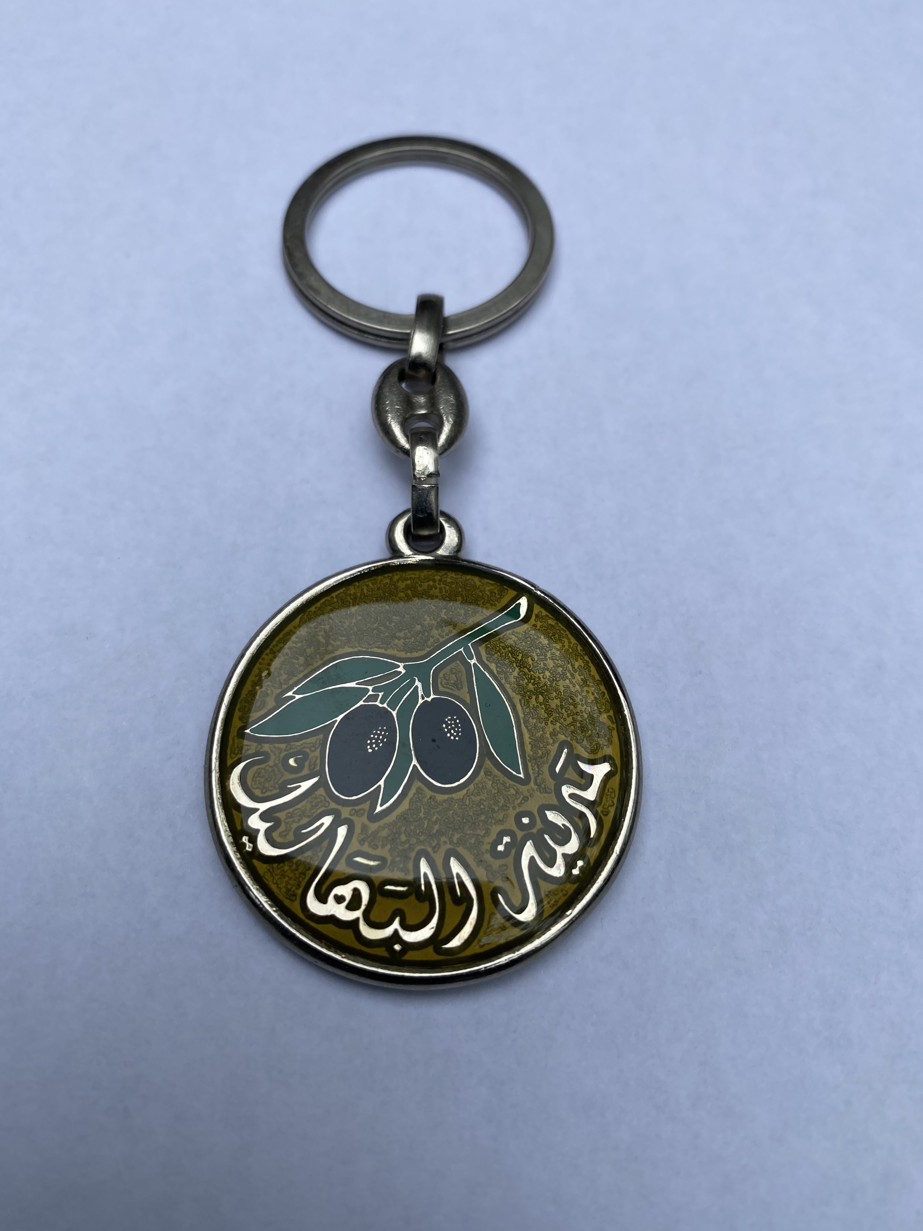
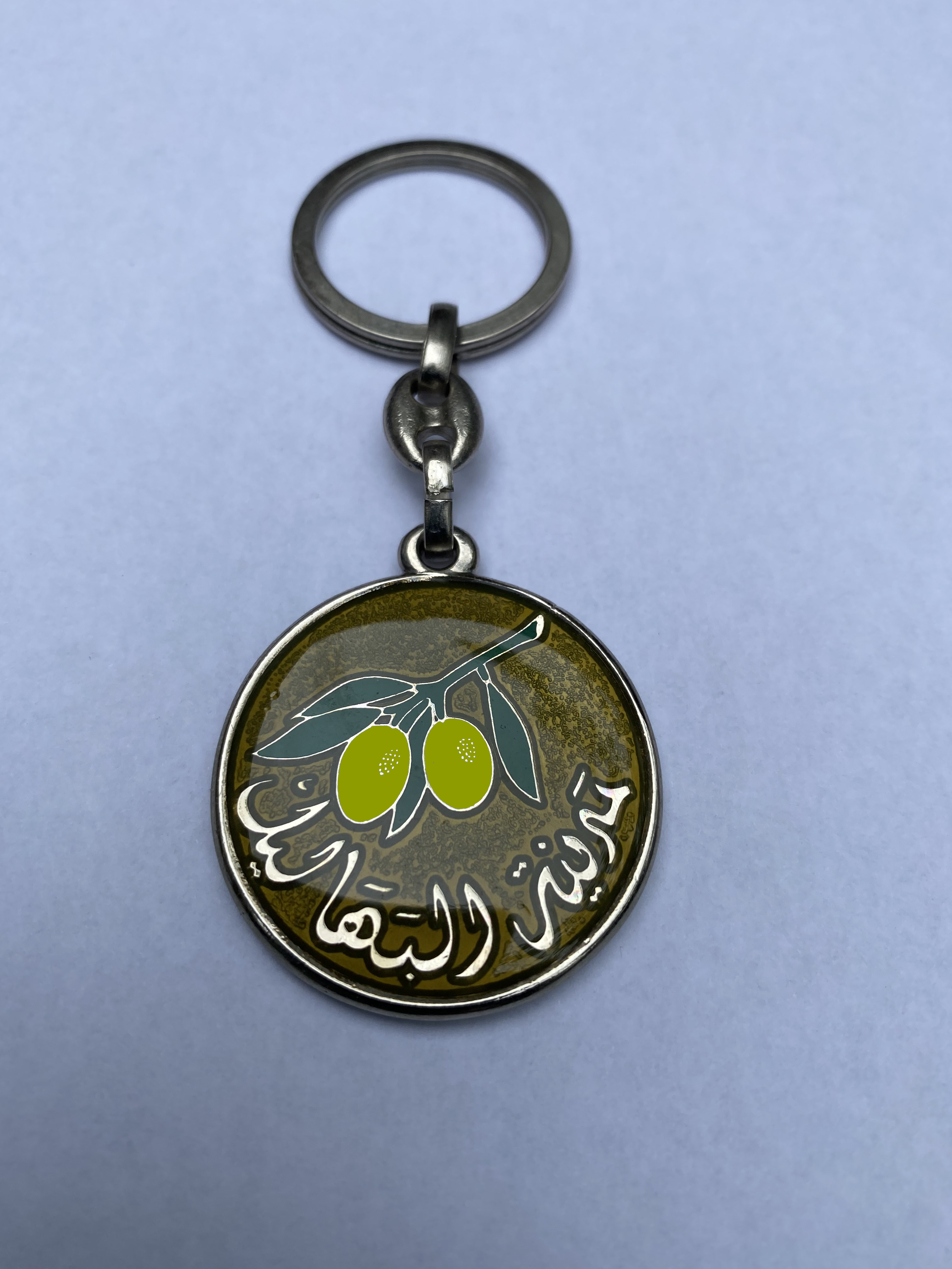
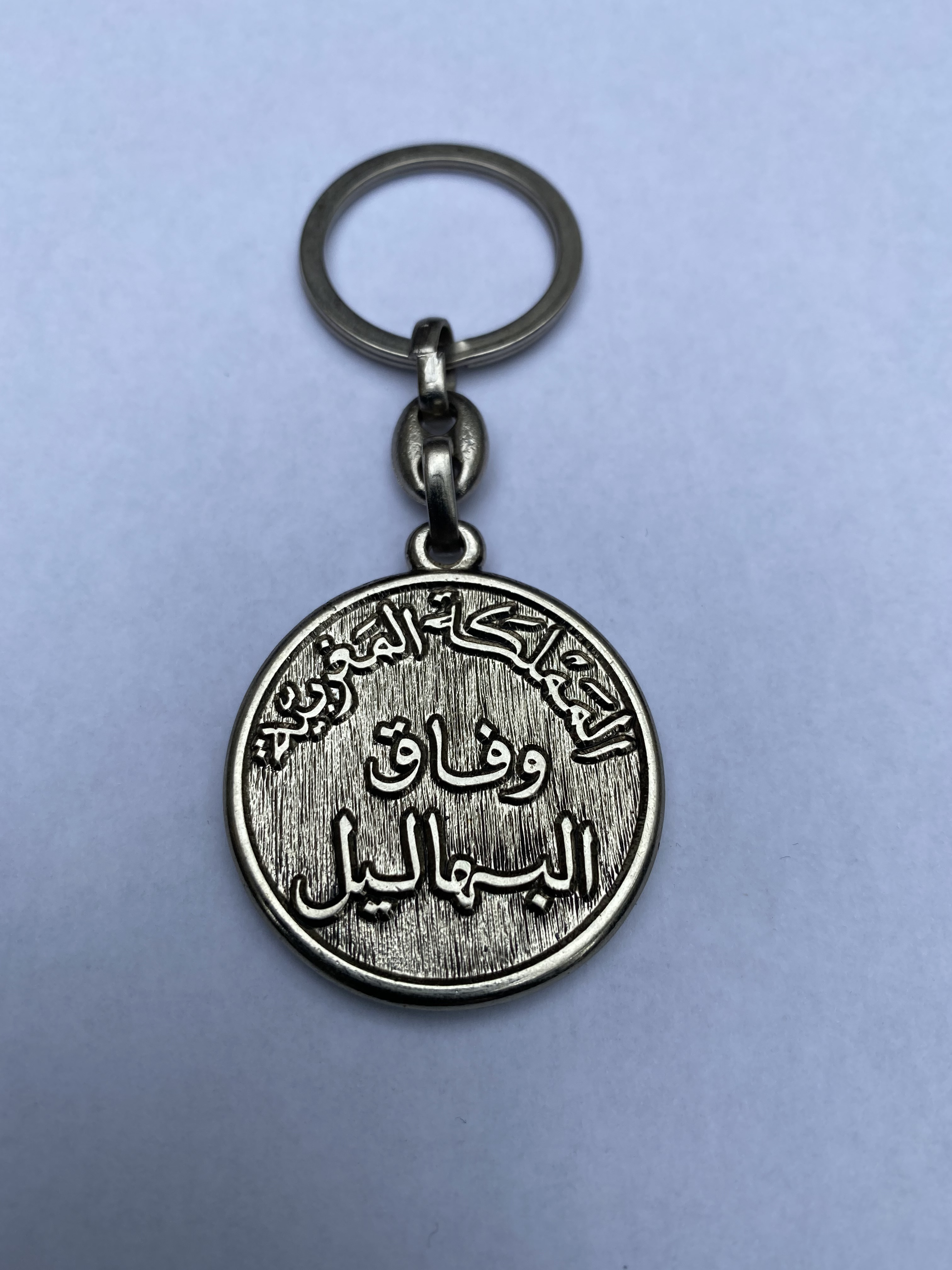
played against teams from neighbouring towns and villages. It was called ‘Wifaq de Bhalil’.
Key rings with the team's emblem were made at the time. I know there were
Black Olives Keyring, since
I have a few. But I can't remember if the
Green Olives Keyring existed. In any case, they have just been created virtually
for this site. I really like these key rings. They bring back good memories. And I am very grateful to
my friends at Wifaq who gave them to me at the time, as well as those who took care of making them
. Here, by the way, is the Back of these Keyrings.

View from and through the pine trees of Aghezdis. 2009 - © 2023
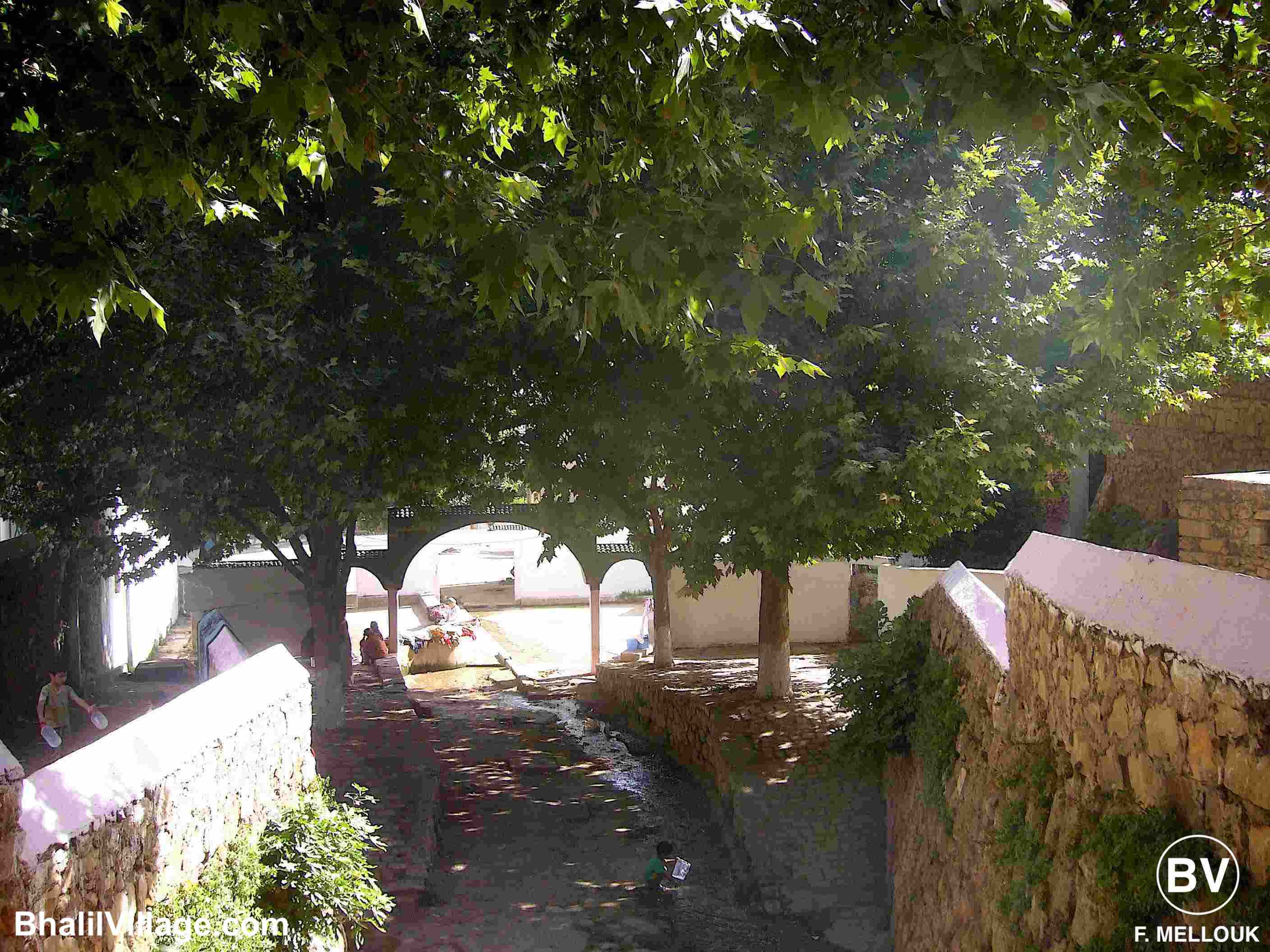
Birthplace and epicentre of Bhalil. 2009 - © 2023

A bit of greenery is always better! 2009 - © 2023

A hidden and mysterious passageway. 2009 - © 2023
The El Addal chasm near the troglodyte village of Bhalil is a natural and unexpected hole in the Jbel Kandar at the foot of the Middle Atlas Mountains in Morocco. A local geological phenomenon that most people in Bhalil are unaware of. Discover it in the form of a true story told following an excursion with friends. To read this story, click on the web page specially dedicated to the legendary El Addal chasm.
GUARDIAN 🔹 TOPOGRAPHY 🔹 RESOURCES 🔹 TOP OF PAGE
PRODUCTION & DESIGN: Fouad MELLOUK ☀ DATE OF PUBLICATION: April 22, 2023 ☀ UPDATE: May 20, 2024 ☀ CATEGORY: Discovery - History - Memory - Memories ☀ DOCUMENTS, IMAGES & TEXT: All rights reserved. No reproduction without express permission ☀ CONTACT: bhalilvillage@gmail.com ☀ COPYRIGHT © 2023